
More Problems With Flood Geology
DAVID F. SIEMENS, JR.
2703 E. Kenwood St.
Mesa, AZ 85213-2384
From: PSCF 44 (December 1992): 228-235. Response: Rust
The view that the Genesis Flood totally revamped the prediluvian world has its proponents contradicting themselves. Their claim that modern mountain ranges arose only after the Flood is in conflict both with common sense and with scientific observations of mountain building. Their theories of the state of the earth before the flood, with an atmospheric "canopy" and a subterranean "great deep," are implausible. Their mechanism for the Flood would produce earthquakes and tsunamis, or even a free fall, that the ark would not survive. As its proponents present it, "Flood Geology" is clearly unacceptable.
In a previous paper, I noted several problems with "Flood Geology" (diluvianism) that should not take special expertise in any of the sciences to understand.1 For example, I noted that Henry Morris, a prominent diluvianist,
 |
claimed both that terrestrial life survived and did not survive outside the ark. He also contradicts himself concerning the flood waters. In one passage he writes:
Even if only the mountains in the immediate vicinity of the mountains of Ararat on which the ark grounded when the waters began to recedeº were covered, it would not have been possible for the flood waters to be retained in the local vicinity. The present Mount Ararat is seventeen thousand feet high, and it was two-and-a-half months after the ark grounded before the tops of any mountains could even be seen. It was an additional 41/2 months before the water level went down enough to let the occupants leave the ark. To imagine that a year-long, seventeen-thousand-foot high flood could have been a local flood is absurd.2
Whereas elsewhere he writes:
The Bible does tell us that one of the most important questions of geophysics--that is, the question of orogeny, of how and when the mountains were formed--must be answered specifically in terms of the great Flood. There were, of course, mountains in the originally created world, but they were relatively low and of gentle slope, not the rugged, uninhabitable ridges of the present world. The waters of the Flood covered these mountains to at least 15 cubitsº Once the antediluvian topography had been leveled by the devastating flood waters, however, and the world completely inundated, then great mountain uplifts began to take place.ºThus, the present mountain ranges of the world were formed during and following the Flood.
The great mountain uplifts, and corresponding ocean basins, would necessarily be accompanied by an abundance of other tectonic activities--faults, folds, thrusts, and earth movements of many kinds.3
Somehow, the waters rise to 17,000 feet (over 5 kilometers) above mean sea level when the universality of the Flood is noted, and a fraction of that when a theory of mountain building is invoked. In the real world, water cannot be nearly 5182 meters deep when the entire terrestrial water supply can cover a smooth globe only by about 2950 meters (9,700 feet), a figure Morris himself notes.4 Since he rejects the theory that water was miraculously created and then miraculously removed, that option cannot be called in to explain the difference.5
Diluvianist Orogeny: Soft Soils and Hard Shakes
If we pass over this contradiction, the crucial element in this diluvianist view appears to be that the rise of mountains is strictly a postdiluvial phenomenon. John C. Whitcomb claims that "suddenly, just after the Flood," the continents and mountains rose.6 Morris makes the rise relatively rapid. But "the transition periodº probably lasted many centuries."7 A major problem arises if one tries to raise recently deposited material to form mountains. Sand, silt and clay, saturated with water, ooze and run.8 For example, we do not need breaking waves to batter sand castles flat. As soon as the flow wets their base, they collapse.
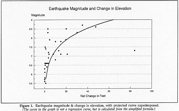
The simple problem of making mud pile up thousands of feet is complicated by the earthquakes that always accompany any faulting that elevates ground. A recent search produced records and estimates for over thirty earthquakes where a relative change in elevation was recorded.9 (See Table 1.)
 |
These are graphed in Figure 1, along with the line calculated from a formula producing a doubling of the rise for every half unit on the Richter scale.10 The most severe earthquakes ever measured had intensities of 8.9 and 9.2. Even though the epicenters were offshore, they caused extreme destruction.11
Additionally, so far as I have been able to discover, earthquake scarps (breaks where vertical faults rise through the surface) seldom extend further than a few tens of miles.12 They are not to be confused with inter-block faults like the San Andreas, whose motion is essentially horizontal. These extend hundreds of miles.
The vertical element must be played against the size of the highlands of which Ararat is a part. They extend nearly 500 miles east and 600 miles west of Ararat, ignoring the nearly continuous ranges extending across Asia. The north-south extent is well over 400 miles. Elevation throughout is over 6000 feet. For simplicity, let us ignore the lower rises on all sides and consider an ellipse 400 by 1000 miles, with an area of about 314,000 square miles. Ignoring further the numerous peaks more than 10,000 feet tall and the greater elevation generally, we posit that the area rose 6000 feet. Let us assume that a magnitude 9 earthquake can raise an area of 1000 square miles 100 feet. Over 18,000 earthquakes as large as any recently observed would have devastated the area. Assuming that the process took two centuries, an average of about 90 great earthquakes a year would have occurred in the area. Unless Noah and his family moved away quickly, they would have had everything they ever constructed shaken to pieces many times over.
 |
A standard formula for the relation between the surface-wave magnitude and the Modified Mercalli Intensity at the epicenter is: M = 0.58I + 1.5 if M = 8.5, I = XII, the top of the scale.13 The description for an intensity of XII reads in part: "Damage is total, and practically all works of construction are damaged greatly or destroyed." Already at XI, "Damage is severe to wood frame structures . . ." At X, "Most masonry and frame structures, and their foundations, are destroyed.14
Of course, the situation just after the rain ceased would have been worse. From the time the ark grounded until the dove found someplace to light was about four and a half months. The earthquake or earthquakes accompanying such a quick rise would have had magnitudes greater than any mentioned above. They would have been more than strong enough to tear the ark apart, especially since the ark rested on unconsolidated strata.
Pre-Flood Geology and Meteorology: "Canopy" and Caverns
What has just been said focuses on the immediate area of the grounding. But Morris has a further source of terrestrial turmoil at the start of the Flood, though he does not spell out its impact. There was a great reservoir of water, the "waters below the firmament."
This was water in the liquid state, visible especially to the first man in the form of the antediluvian seas (Genesis 1:10) and rivers (Genesis 2:10-14). These rivers were not produced by run-off from rainfall (Genesis 2:5), but emerged through controlled fountains or springs, evidently from deep-seated sources in or below the earth's crust. . . .
Such subterranean reservoirs were apparently all interconnected with each other, as well as with the surface seas into which the rivers drained, so that the entire complex constituted one "great deep." The energy for repressurizing and recycling the waters must have come from the earth's own subterranean heat implanted there at the Creation. . . .
When the time for the destruction of this world arrived, however, all that was required was to bring the two "deeps" together again, as they had been when first created. The waters above the firmament must be condensed and precipitated, and the waters below the crust must burst their bounds and escape again to the surface.15
This appears to require that the antediluvian continents collapsed into the reservoirs lying beneath them. Then the waters from these caverns plus the waters from the ancient seas and those condensed from the primordial "canopy" swamped the ancient land.
This "canopy," according to diluvianists, represents "the waters which were above the firmament" (Genesis 1:7). At one time, various authors held it to be a spherical layer of either ice or water above the atmosphere.16 Such views run into two problems.
First, the only way we know that something can be "held up" in the required position is to have it in orbit. But there is no way that a solid spherical shell can be in orbit around the earth. All its parts would have to be in polar and equatorial orbits simultaneously, essentially moving in every direction at the same time. Second, such a structure would have to be within the Roche limit. The consequences of being within the Roche limit are visible in the rings of Saturn: bits and pieces. There were some who suggested that the "canopy" could be Saturn-like rings around the earth made up of fine bits of ice.17 But this could not have had the required effect on the climate. So the current view has generally changed.
For Morris, the "canopy" was composed of clear water vapor, not the condensed droplets that form clouds. This could be supported by the lower atmosphere. Since pure water vapor is lighter than air, it could float, provided the gases could have been kept from mixing.18
According to the diluvianists, the resultant greenhouse effect eliminated all wind and rain storms. The temperature would have been much warmer, and quite even from poles to equator. The total atmosphere (air plus "canopy") would have been deeper and consequently denser at the surface. The total mass of the current atmosphere is estimated as 5.1 to 5.7x10¹⁵ tons. Only a small part of this is moisture, approximately 0.5%. The total mass of water in earth's oceans is about 1.6x10¹⁸ tons. Therefore, if only a third of the water in the modern oceans were part of the earth's atmosphere, the atmospheric pressure at the surface would be greater than that of Venus.
A more realistic possibility, assuming the "canopy" did exist, might be to have as much as 1.5% of the current oceanic water in the "canopy." This would raise the atmospheric pressure at the surface of the earth to about what is considered the maximum safe pressure for scuba divers. Indeed, the only figures I have found suggested by Morris in this connection would be half or less of the 1.5%.19 If the maximum 1.5% of oceanic water condensed out of the "canopy," the water level world-wide would rise no more than 140 feet. The water would rise only 50 to 70 feet if Morris's figures are used. Since the highest peaks were covered by 15 cubits of water at the height of the flood (that is, over 20 feet), the antediluvian mountains could have had an elevation no greater than 120 feet, provided that the "canopy" be the only source of water for the Flood. We cannot reasonably assume every mountain was so low, let alone 30 to 50 feet, especially since the continental area is claimed to be at least three times greater than today. Hence we must seek another mechanism to provide enough water for a total inundation.
The mechanism suggested comes from the "waters which were under the firmament" of Genesis 1:7. When the dry land appeared out of these waters, Morris argues, "an intricate network of channels and reservoirs opened up in the crust to receive the waters retreating off the rising continents."20 These subterranean reservoirs connected to the antediluvian seas to form a unified system.21 The reservoirs were pressurized so that they could provide flows at artesian springs great enough to feed the four rivers of Eden.22
Morris's description raises some problems. First, he claims that the ancient seas were much smaller than the present oceans,23 and the ancient hills were low.24 He does not speculate on how much smaller or lower. For the sake of argument, let us imagine that the highest of the ancient hills were only about a thousand feet high. For the ancient oceans, let us approximately reverse the current proportion of land and water, but retain the current average depth. In this case, about 30% of the ancient surface was oceans. They would hold about 40% of the water in today's oceans. With no more than 1.5% of the water in today's oceans in the ancient "canopy," we must find space for nearly 60% of the currently available water in the subterranean reservoirs. This requires an average of over 1.3 cubic miles of water under every square mile of land. One may consider enlarging or deepening the oceans. But enlarging the oceans is not compatible with the need for vast amounts of vegetable material to be compacted into coal.25 Deepening the oceans does not seem go along with a low profile for the land areas. Also, the ocean bottom is already probably lower than the bottom of the subterranean caverns.
However one tinkers with the seas, the proposed caverns will be large. Consequently, we must support the overlying land. Otherwise, it will fall through the water to the bottom of the caverns.26 This may be one reason why Morris suggests that the caverns were pressurized. On the one hand, this would help to support the earth above. On the other, it would allow for massive artesian springs to feed the rivers of Eden.27 But there are problems with the diagram of the water system given by Morris.
With no more than 1.5% of
the water in today's oceans in the ancient "canopy,"
we must find space for nearly 60% of the currently available water in the
subterranean reservoirs. This requires an average of over 1.3 cubic miles
of water under every square mile of land.
In this system, the lower reaches of the sea are connected by insulated passages to the "Great Deep," the subterranean reservoirs, located at a lower level. The top of the reservoirs are connected to the surface of the earth at the top of a mountain by a large conduit. Heat flowing from deep in the interior of the earth warms the water in the "Great Deep," causing it to rise through artesian springs large enough to supply the rivers of Eden.28 But warmed water will rise through any passage that trends upward, and sea level is lower than the tops of the hills. No wonder Morris elsewhere speaks a "system of reservoirs, valves, governors, and conduits."29 But merely adding valves will not produce a one-way flow with constant heat. Intermittent heating plus valves can produce a pulsing flow. But there seems to be no way to get the heat of the earth's interior to change rapidly enough to provide adequate pumping, despite the assurance that the system "is quite feasible."30
A geyser-like mechanism could raise water the thousand feet suggested ... However, at the lowest hyperbaric pressure suggested by Morris, the temperature would still be about 230ƒ . Rivers or lakes this hot could not benefit plants.
There are, however, two ways in which constant heat in part of a simple system can raise water the thousand feet suggested for the mountains. A geyser-like mechanism would work. Geysers are in principle simple; little more than a deep hole in the ground, requiring no valves or cycling rock temperatures. The cycle comes simply from the flow of water. The only problem is that a geyser depends on superheating water at the lower levels so that it flashes into steam as the water above it is discharged.31 Under the higher atmospheric pressure suggested earlier, the exit temperature of the water would be about 290ƒ F, much hotter than a hospital autoclave. At the lowest hyperbaric pressure suggested by Morris, the temperature would still be about 230ƒ . Rivers or lakes this hot could not benefit plants.
The second way requires some explanation. The antediluvian climate, according to the theory, was affected by the "canopy." So I assume that the worldwide temperature was much like that of today's tropical islands, whose average annual temperature is about 77ƒ F.32 With the ancient air temperature essentially the same everywhere, the water temperature of all the seas would be like the air temperature, especially since there could be neither a mineral-concentration density gradient in a fresh-water ocean, nor a temperature-driven density gradient with the same temperatures worldwide. These gradients control deep-water currents in today's oceans. So 77ƒ is the input water temperature assumed. The temperature of the output water is restricted by its potential effect on the plants it will water. So let us consider an upper limit of 100ƒ F. Water at 100ƒ is slightly lighter than water at 77ƒ .33 So it is possible to balance a taller column of warmer water with a shorter column of cooler. To get the one column to the top of hills a thousand feet above sea level requires that the warmer column be over 46.25 vertical miles deep, and no place less than 100ƒ . From sea level down to the bottom of the U the shorter column, the temperature can nowhere be more than 77ƒ . The first problem here is that these calculations are for a static balance. If water is to flow from the upper end, the cold water column must be deeper. Second, no matter the diameter of the columns, friction will strongly interfere with the flow. So the depth must be much greater, although this produces yet more friction. Third, temperature rises with depth: 131ƒ F at the 12,391 foot depth of the deepest mine; 392ƒ 6.82 miles down in the exploratory well on the Kola Peninsula, northern Russia.34 So keeping the temperature below 77ƒ for well over 46 miles down into the earth seems unattainable. Of course, with lower mountains, the column could be proportionally shorter. However, I find it difficult to imagine continents with no rise higher than a thousand feet above sea level. Indeed, it seems more likely that they would be higher.
The Smashing Deluge: Inverting Land and Water
But now, ignoring the problems just noted with the mechanisms suggested for the "waters which were under the firmament," we return to their part in the Flood. It appears that, on the theory proposed by the diluvianists, either a majority or the whole of the ancient earth's continental surface dropped into the subterranean cavities during the 40 days when the waters rose. On the most generous estimate, the "canopy" could not produce more than 150 feet of rain, and perhaps could only be responsible for 50 feet. The dry land, granting thousand-foot hills, may be assumed to have an average elevation of 500 feet. To inundate the entire area would then require an average drop of 350 to 450 feet. The most elevated parts would have to drop 850 to 950 feet, plus the 15 cubits of Genesis 7:20. Of course, if there were an average of 1.3 cubic miles of water under every square mile of continent, as noted above, the drop would average over 6800 feet. If we assume the empirically based formula for the relationship between earthquake magnitudes and terrestrial rise or fall, magnitudes of 11 or 12 are minimal.35 These would be many times greater than any this century.
Additionally, if the ark were to float early in the flood period, the support would have to drop from under it. So at least one of these devastating earthquakes must have been centered near the location of the ark. Sitting over the epicenter of a great earthquake would have damaged the ark seriously, knocking it apart however it was built.
In the diluvianist
theory, we have over a hundred million square miles of land
dropping over a mile. Nothing sitting on shore could survive
either the inciting earthquakes or the resulting waves.
Further, earth dropping into water has generated the greatest waves known. On July 9, 1958, a magnitude 7.9 earthquake caused landslides to cascade into Lituya Bay, AK. The resulting wave rose 1740 feet.36 So it is hard to imagine what riding a block down into the subterranean caverns might have done to the ark.
On the other hand, if there were a collapse along the coast before the ark was afloat, a tsunami greater than any ever recorded could have been generated. In the 1883 eruption of Krakatoa, most of the island's five square miles collapsed into 820 feet of water. Waves some 115 feet high slammed into neighboring coasts, killing 36,000 people.37 In the diluvianist theory, we have over a hundred million square miles of land dropping over a mile. Nothing sitting on shore could survive either the inciting earthquakes or the resulting waves.
A Summary of Impossibilities
The time for some decisions has arrived. First, the change of parameters in some arguments means that they fail to support diluvianism. Second, the difficulties raised by the connection between earthquakes and the rise of mountains have not, to my knowledge, been carefully evaluated. Similarly, apart from abandoning the notion that the "canopy" was a solid shell of ice, the restrictions on the amount of water that could be in the "canopy" have not been thought out. It has been assumed that almost any amount of water could be placed in the upper atmosphere, ready to condense into hundreds or even thousands of feet of water to cover the entire earth.
Furthermore, the consequences of the amount of water that this theory requires to be stored under the antediluvial continents was not explored. Certainly the mechanism of the water cycle without precipitation was not adequately analyzed. Various matters, like the amount of vegetable material needed for the production of coal by a single event, the Flood, which were mentioned in notes, add to the total set of problems. Finally, the problems of a total collapse of the ancient continents have not been faced in the diluvianist literature.
Unless each of the total set of problems noted in this paper, to which may be added the problems of my earlier paper, is clearly answered, the diluvianist system is shown to be, for all practical purposes, impossible. If Morris, Whitcomb, Gish, Austin, and their fellows hope to rehabilitate diluvianism, they will have to rethink it from the beginning. They can be given no assurance that their effort, however sustained, will be successful.38
©1992
NOTES
1 F. Siemens, Jr. Perspectives on Science and Christian Faith, pp. 169-174, Vol. 44, No. 3, September 1992.
2 Henry M. Morris, Science and the Bible (Rev. ed.; Chicago: Moody Press, 1986), pp. 64f. See also idem, The Genesis Record: A Scientific and Devotional Commentary on the Book of Beginnings (Grand Rapids, MI: Baker Book House, 1976), p. 201. References to these books will be to Science & and Genesis Record, respectively, in subsequent notes.
3 Idem, The Biblical Basis for Modern Science (Grand Rapids, MI: Baker Book House, 1984), p. 259. This book will be referenced as Biblical Basis in subsequent notes.
4 Ibid., p. 287.
5 Genesis Record, pp. 195f
6 John C. Whitcomb, The Early Earth: An Introduction to Biblical Creationism (Rev. ed.; Grand Rapids, MI: Baker Book House, 1986 [2nd printing, 1989]), p. 80.
7 Biblical Basis, p. 287.
8 See Bryce Walker, Earthquake, (Alexandria, VA: Time-Life Books, 1982), pp. 27, 32f, concerning what can happen when layers of clay are shaken and liquefy.
9 Jerry L. Coffman et al., eds., Earthquake History of the United States (rev. ed. with supplement; Boulder, CO: U.S. Department of Commerce, NOAA, and U.S. Department of the Interior, Geologic Survey, 1982). James M. Gere and Haresh C. Shah, Terra Non Firma: Understanding and Preparing for Earthquakes (New York: W. H. Freeman and Company, 1984). "Whittier Narrows Earthquake," Science, 239:1355 (18 March 1988).
Not included is the 750-foot change for the 1923 Kwanto earthquake in Japan. Gere and Shah do not mention it. John H. Hodgson, Earthquakes and Earth Structure (Englewood Cliffs, NJ: Prentice-Hall, Inc, 1964), p. 20, notes that the report is probably mistaken. Yoichiro Fujii and Katsumi Nakane, "Anomalous Crustal Strain Prior to the 1923 Kanto, Japan, Earthquake as Deduced from Analysis of Old Triangulation Data," Pure and Applied Geophysics, 117:1301, 1313 (1979), give the magnitude as 7.9 and vertical displacement as less than 140 cm.
Note that all magnitudes for earthquakes before about 1900 must be estimates. Seismographs were first developed about 1890. The Richter scale was developed in 1935. Note also that only vertical changes are noted. Many earthquakes involve horizontal movement, which, though important, cannot be quantified for the purposes here.
To minimize the effect on the diluvianist view, both subsidence and elevation are included. When both a rise and a fall are given, their absolute values were added, thus giving a maximum change for the associated magnitude, even though slumping cannot help to raise a mountain.
10 The formula for the rise in feet, R, for each Richter magnitude, M, is R = 2(2 x (M-6)) It gives a rise of 64 feet for a magnitude 9 earthquake. To give the benefit of any doubt to the diluvianists, I assume a 100-foot rise.
11 See Gere and Shah, op. cit., pp. 178f, for two measuring 8.9: Ecuador, 1906; Japan, 1933. The 1964 Alaska quake measured 9.2. Richard A. Kerr, "Big Squeeze Points to a Big Quake," Science, 252:29 (1991). Elsewhere, the last magnitude is given as 8.3-6 or 8.4. See, for example, Walker, op. cit., pp. 33f.
12 The longest rise, about 100 miles, is associated with the 1964 Alaska earthquake. It is here taken as a single event with 8.3 magnitude, the lowest found in the literature (see note 11). Actually, six major, separate ruptures occurred along about 150 miles of fault, plus some 12,000 after shocks, including 17 with a magnitude equal to, or greater than, 6. For about 100 miles, the sea floor rose an average of six feet. In a parallel arc, the land dropped between 2.5 and 7.5 feet. An estimated 48,000 square miles subsided; 60,000 rose. See Walker, op. cit., pp. 32-35. On the most generous assumptions, given the data, the average rise over 108,000 square miles was about 2 1/4 feet. The average is more likely about one foot. A figure of 30 feet was entered in the table and graph.
This data shows that the analysis of the connection between magnitude and rise is complex, something that is demonstrated also by the small shifts for other major earthquakes. My analysis is crude and simplistic. Yet it furnishes an empirical base for analysis which generally favors the diluvianist position.
13 See W. H. K. Lee and D. R. Brillinger, "On Chinese Earthquake History--An Attempt to Model an Incomplete Data Set by Point Process Analysis," Pure and Applied Geophysics, 117:1232 (1979).
14 "Earthquakes and Seismology," Van Nostrand's Scientific Encyclopedia (5th ed.; New York: Van Nostrand Reinhold Company, 1976), p. 850.
15 Genesis Record, pp. 194f. See also Biblical Basis, pp. 258f; Science &, pp. 81-84.
f "below the earth's crust" is taken literally, the "waters below the firmament" would extend downward over twenty miles. As a consequence, the volume of falling rock in the computation in note 36 could be 200 times greater, adding 1.5 to the computed magnitude.
16 Genesis Record, p. 59.
17 Ibid.
18 The density of a gas is proportional to its molecular weight. This is approximately 18 for water; and about 28 for nitrogen and 32 for molecular oxygen, which make up the bulk of the atmosphere. There is a pattern in the current atmosphere which may be used as a hint for a "layer" of gaseous water. Atomic oxygen (relative weight 16) is a major constituent of the rarefied atmosphere about 60 miles up, becoming the major constituent above 120 miles. Much higher is a layer of helium (4) and then a layer of hydrogen (molecular, 2; atomic, 1). See "Atmosphere," Van Nostrand's Scientific Encyclopedia, p. 215.
19 See Genesis Record, pp. 59-61, 85, 142f, 194; Science &, pp. 82-84; Biblical Basis, pp. 286f.
20 Biblical Basis, p. 280.
21 Biblical Basis, p. 281.
22 Biblical Basis, p. 281. Genesis Record, pp. 88f.
23 Biblical Basis, pp. 286f.
24 Ibid., p. 259.
25 World coal reserves, not including lignites, are estimated at 5.3x10¹² tons. Lignites are estimated at 1.3x10¹² tons. If we assume that only 50% of the coal and 25% of the lignite is carbon (although anthracite runs 92-98% fixed carbon, and bituminous as high as 86%), that all of the carbon came from cellulose and similar plant products, that the conversion of cellulose to coal lost no carbon, and that the land area of the prediluvial world was 70% of the total surface area, each ancient acre needed to be covered with over 60 tons of plant material. Obviously, the assumption of 100% efficiency at every stage in the process is ridiculous. So corrections for losses have to be inserted. A total factor of 3 or 4 is hardly sufficient. But that is the maximum that the data will allow. The biomass of today's tropical rainforests is usually about 160 tons per acre, with one area perhaps reaching 200. See Paul Westmacott Richards, "Ecosystems: Jungles and Rain Forests," Encyclopedia Britannica 1986), 17:1034. No temperate forests except those of mature redwoods top 140 tons per acre. See Geoffrey Kenyon Eliott, "Ecosystems: Boreal and Temperate Forests," ibid., p. 1009.
The computations above do not provide for the grazing animals, who normally live on savannas or prairies. Grasslands have a biomass a small fraction of that of forests. Nor is there any place for agriculture. Including these would reduce the potential loss factor appreciably.
The figures for biomass cannot be equated to productivity in any simple way. In the dense growth of tropical rain forests, young trees cannot survive unless the fall of an old tree allows light to penetrate the dense canopy of leaves. So even if growing conditions were better because of more light, more water, greater warmth, the standing biomass can hardly exceed 200 tons per acre.
26 Probably a quarter of the underearth area will have to be taken up by supporting columns of rock. The bottoms of the caverns will then be about 1.7 miles below sea level or, on the assumptions made, about 1.8 miles below the average land surface.
27 Genesis Record, pp. 88f, 194f, 207. Biblical Basis, p. 281.
28 Biblical Basis, pp. 281-283.
29 Genesis Record, p. 195.
30 Genesis Record, p. 195.
31 "Geyser," Encyclopedia Britannica (1986), 5:231.
32 From data in Hammond Ambassador World Atlas (Maplewood, NJ: Hammond Incorporated, 1984), pp. 480f, for Apia, Western Samoa; Bali, Indonesia; Havana, Cuba; Kingston, Jamaica; Las Palmas, Canary Is.; Noumea, New Caledonia; Papeete, Tahiti; Port-au-Prince, Haiti; San Juan, PR. Also for Honolulu, HI, from Information Please Almanac (Boston: Houghton Mifflin Company, 1990), p. 670. The range of average annual temperature was 69-82.
33 Robert C. Weast, ed., CRC Handbook of Chemistry and Physics (62nd ed.; Boca Raton, FL: CRC Press Inc., 1981), p. F11, gives the density of pure water as 0.99707 gm/ml at 25ƒ C = 77ƒ F, and 0.99299 at 38ƒ C = 100ƒ F. The lengths equal 74.182 and 74.487 km. Were one able to use water at maximum density at 3.98ƒ C and at 100ƒ C, the longer arm would be only a little over 4 1/2 miles from surface to depth.
34 Norris McWhirter, ed., 1986 Guinness Book of World Records (24th ed.; New York: Sterling Publishing Co., Inc., 1985), pp. 198, 197. This measured rise is approximately half that of 1ƒ F for 55 feet given by D. W. van Krevelen, "Fuels: Coal," Encyclopedia Britannica (1986), 19:603. Weast, op. cit., p. F-163, is even higher at 86ƒ F per mile. But he tags it "uncertain."
35 On the diluvianists' theory, over a hundred million square miles of land had to drop nearly a mile and a half within a 40-day period. If the figures for area and elevation I have earlier suggested are taken, more than 140,000 square miles every hour disappear beneath the waters. Assuming an average thickness of 500 feet for the land above the reservoirs (too small to be realistic) and a specific gravity of 2.6, I calculate this to release a minimum of 3.6x1026 ergs per minute. This energy is equivalent to about a magnitude 10.1 earthquake every 60 seconds for the entire 40 days. If the release were not in these minute-sized packets, or if we take more realistic figures for the mass of land above the "Great Deep," the power of each earthquake could rise to even higher levels. Yet one can figure 10.1 as three Mercalli intensities beyond the total destruction of the top of the scale.
The formula, from Charles F. Richter, "Earthquakes," Encyclopedia Britannica (1986), 17:621, is: log E = 11.4 + 1.5M where E is the energy in ergs and M is the Richter magnitude. Bolt, op. cit., p. 249, with Ms as the Richter surface magnitude, gives: log E = 11.8 + 1.5Ms
36 Walker, op. cit., p. 31. Coffman, op. cit., pp. 107f.
37 Coffman, op. cit., p. 107. Gere and Shah, op. cit., p. 52.
38 Thank you, referees, for useful suggestions.
Note added in proof: The June 28, 1992, Landers, CA, earthquake, magnitude 7.5, produced a 2 meter (about 6.5 foot) scarp pictured in Time (August 24, 1992), pp. 54f.